Before GPS
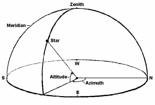
As early as 1200 B.C., navigators were able to determine their positions and destinations using celestial navigation (Heyerdahl, 1978, Macleod, 2010), and it is clear that throughout the ages, at least since 532 B.C. navigators had knowledge of how to determine their latitude (Pinotsis, 2005), which is a position on earth ninety degrees north or south with regards to the equator, as well as how to maintain their latitude through celestial navigation (Iowa State University, 2000). “One's position on earth could be ascertained relative to a star (fixed point) by measuring the angle of elevation (altitude) of the star from the observer (apex) and the earth (horizon)” (Cardoza, 2006, p.7). In other words, (see illustration) the position is directly below the zenith, which is at a ninety degree angle to the horizon, which circles around in all directions, referred to as azimuth.
On the azimuth, north is zero
degrees, east is ninety degrees, south is 180 degrees, west is 270 degrees until it comes full circle to north again at 360 or zero degrees (Blewitt, 1995; Iowa State University, 2000). The altitude of the star from the horizon, is measured in degrees and azimuth direction and provides the latitude of the observer’s or navigator’s position. Up through the invention of the modern day sextant, many ancient explorers not only knew where they were, but they also knew where they were going, and they had some idea of how to get there, or how to navigate (Heyerdahl, 1978; Macleod, 2010). This was done by using some variation of measuring the geometric angles of celestial bodies’ positions in relation to earth, as in the above illustration (Clark, 1993; Ifland, 2000; Pinotsis, 2005). The instruments used to measure these angles evolved, sometimes separately, until the development of the marine sextant in 1759 by John Bird, which was based on Hadley’s octant but with a larger range of altitude (Ifland, 2003). When used in concert with a nautical almanac, chronometer, a nautical chart with lines of latitude and longitude marked, and a mathematical method for translating celestial observations onto nautical charts (Ifland, 2003), the modern sextant enabled navigators to pinpoint their latitude and longitude or global coordinates, making it the standard for navigation for the next 200 years (Ifland, 2003).
x
x
