Changes in Latitude Determination
All precursors to the sextant seem to have a basis, whether instinctual or mathematical, on the geometry of a circle. Although in reality it is the earth, planets and stars revolving around the sun, for the practical purposes of navigation, it is easier to think in terms of the earth being fixed, and that the stars will not seem to move over a brief period of time, yet the sun and moon will (Blewitt, 1995; Clark, 1993). At any moment in time, the sun is directly overhead in one place, that is its global position and it changes constantly. Polaris, the Big Dipper, has its own global position and really does not change, it is at 89 degrees 05’N latitude. From any point north of the equator, navigators could find Polaris on their meridian and determined their latitude by measuring the altitude of Polaris above their horizon (Blewitt, 1975; Clark, 1993; Iowa State Univeristy, 2000).
Taking a Sun Sight at Noon
Another easy method for determining
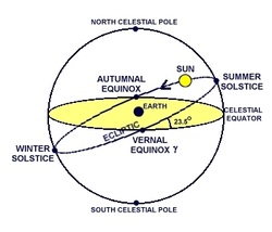
latitude was spotting the sun at noon, the
moment when it was due south of them, again on their meridian. However, navigators had to take into account the time of year and correct for declination of the sun. That is the highest point of latitude that it will reach in the sky on any particular day, or its zenith, and it will vary between 23.5 degrees north of the equator during the summer solstice, and 23.5 degrees south during the winter solstice. During the equinoxes, the sun’s declination will be zero as its zenith is directly over the equator on those days (Blewitt, 1995; Iowa State University, 2000). The distance between the horizon and the sun or pole star nearest the position on the meridian, after correction for declination is the latitude. If the latitude and declination are both on the same side of the Equator, then the equation is:
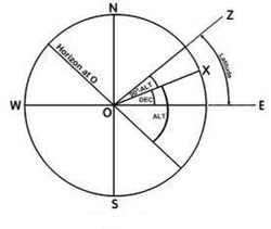
LAT = DEC + (90o – ALT). This is also called "Shooting the Sun".
Even before instruments measured the actual degrees of latitude, navigators could notch or mark their position on their instruments and know that to get home, they needed to match that measurement (Clark, 1993; Ifland, 2003).
LAT = DEC + (90o – ALT). This is also called "Shooting the Sun".
Even before instruments measured the actual degrees of latitude, navigators could notch or mark their position on their instruments and know that to get home, they needed to match that measurement (Clark, 1993; Ifland, 2003).
