The Missing Link
The Chronometer
However wonderful the sextant was, there was still a piece of the puzzle of determining position missing. Without a way to measure longitude, the place on the globe east or west of the Greenwich Meridian (Blewitt, 1995), navigators were still limited in their knowledge, exploration and charting (Sobel, 1998). It wasn’t until 1773, when John Harrison invented the chronometer, a method for keeping time, that navigation became precise (Sobel, 1998). Once sailors could measure time, they could determine their speed equals distance equation, as well as determine how far east or west they were of their starting or destination point (Blewitt, 1995; Sobel, 1998).
Nautical Almanac
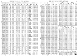
One page of a nautical almanac.
To determine position, the navigator first notes the dead reckoning (DR) position, then uses the Nautical Almanac to pinpoint where a specific celestial body is at that moment in time (Blewitt, 1995; Chapman, 1969). Time in the almanac is Greenwich Time, or Universal Time, which is equal to Local Time plus or minus one hour for each fifteen degrees of longitude east or west of Greenwich’s longitude of zero degrees (Blewitt, 1995). However, longitude may be exactly what the navigator is trying to discover, so the Nautical Almanac fills in the pieces of the puzzle (Blewitt, 1995). To take a sun sight in winter, a navigator would measure the altitude of the sextant and the time. Then corrections would be made for sextant errors such as the dip, which refers to the distance the observer is from the horizon (Blewitt, 1995; Bowditch 1976). For instance, the eye of a navigator standing on the deck of a ship may be ten feet off of the ocean. The correction to the sextant altitude would then be for twenty feet which equals 3’ using the Altitude Correction Table in the Nautical Almanac (Blewitt, 1995; Bowditch, 1976).
Plotting Tools

Calculating longitude and position require understanding nautical almanacs, adjusting for errors, declinations, and star charts, and that is just to identify a position, not plot a course (Blewitt, 1995; Cardoza, 2006). The sextant allowed for really precise measurements of distances and altitudes, which opened the calculations necessary to actually get a “fix” on a position (Bowditch, 1976). When combined with the spherical trigonometry of the navigational triangle: the spherical triangle with a side for polar distance, or the angular distance between the global position of the star; the colatitude which is the angular distance between the pole and the navigator; and the coaltitude, the distance between the navigator and the star (Clark, 1993), the sextant allowed for extremely precise calculations of latitude (Ifland, 2003).
